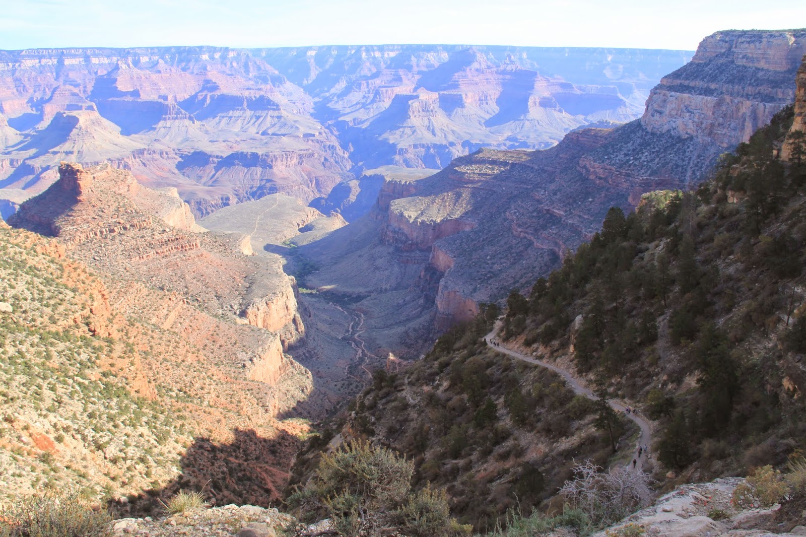
My big adventure...walking the North Rim to the South Rim at the Grand Canyon. It's only about 10 miles across as the crow flies. 23.4 miles if you walk it. I did a lot of research on which trails to take. My brother Bill who previously did this walk had tons of information. Reading this information was a great help in getting prepared... I was ready. (not really)
PREPARATION: Training started a couple of months prior to the big walk. Up early and walked on the paths surrounding the local golf course. Would do at least one hour a day with 1/2 to 2 hour walks daily. First few weeks of training was good, got somewhat tired but okay. After a couple more weeks started feeling really good and thought with my daily walk and a few long training walks I was prepared.
SUPPLIES: Carried a large Mountain Smith fanny pack with shoulder straps. Plenty of room for all my needs. Had two walking sticks. Had a compass, small thermometer, camera, flip video camera, and ipod. Used a wide brim walking hat that I also could attach a sun screen for my neck during the hot part of the day. Carried one map of the Grand Canyon and sunglasses with attachment for looping around my neck. Brought along some tylenol, sunscreen, vaseline. Had 3 pairs of socks and a poncho.
FOOD: Brought along crackers, peanuts, candy, gum, jerky, and cookies. Carried about 3 liters of water. One liter of power aide.
(Please note: To enlarge the pictures, just click on it.)
May 16,2013 4:30 am Ready to roll.
From trailhead to Phantom Ranch about 1 mile down in elevation change.
Map of North Kaibab to Phantom Ranch approx 14miles.
5:10 am Start of North Kaibab Trailhead
At Coconino Overlook 6ish
View of canyon walls on the way down.
Supai Tunnel 1.7miles
Some of the trails and switchbacks going down the trailhead. FYI, since you cannot walk straight down or up, the switchbacks are parallel with canyon walls so you can up or down, obviously going down is easier.
Looking at the first crossover bridge still traveling down the trail.
Bridge in the Redwall.
Around 7:30 am still looking good and yes still going downhill.
This is a HARD trail, imagine walking up or down on that track, I would guess about 20 to 30% of the trail is like this, really hard on the legs. Also, you have to watch where you're stepping all the time.
Easy trail, good to go. This area is around Roaring
Springs about 5 miles into the adventure, you are definitely at the bottom of the Canyon, the
the terrain is slight up and down. You travel about 12 miles headed toward Cottowood Campground, then Phantom Ranch.
Down at the bottom still headed for Cottonwood. You can
camp here overnight if you have a permit.
Views while walking to Phantom Ranch.
Prior to reaching Phantom Ranch you go through an area called the BOX, a couple of milea of good trails, but the canyon walls are very narrow, gets extremely hot.
Pictures of the BOX, it was starting to get warm. About noon time. The trail cuts back and forth to each side, so sometimes in the shade, some in the sun...glad to get through before big heat.
Made it to Phantom Ranch, Approx 14 miles. They have cabins you can rent, also ice drinks and boy do they taste good. Took a good break, ate, rested. About 1 pm. One hour behind schedule.
Break is over, refreshed and ready to go. Note I finally took off my long sleeve shirt, also put on some sun screen for the next part and the heat. It will be back on later, it does get cooler later.
Yuk, the hard walk up and up 4500 ft up and up. Now
the fun starts. Only 9 miles to go.
You leave Phantom Ranch, Bright Angel Campground,
still level headed for Devil's Corkscrew and the first big up.
On the Silver Bridge, Colorado River. Put a scarf on my hat for the sun. It's fixing to get hot. 96 when I left Phantom Ranch. That smirk... this is easy...will soon be gone. Trust me.
View from the Silver Bridge
Back looking at Silver Bridge. Start of Devil's Corkscrew.
Starting the climb up the Corkscrew, looking back at the Colorado.
Nearing the top of Devil's Corkscrew. See all the switchbacks. It's still hot.
Yeah, where's that smirk now? Getting a little tired!
Made it through Devil's Corkscrew, slight reprieve headed towards Indian Gardens last 5 miles. Note the change in scenery. It's getting close to 7 pm. Been out for 14 hours.. 2/3 hours behind schedule.
Entering Indian Gardens.
Leaving Indian Gardens. Yikes looking ahead to
the big climb. If you look at the elevation map you can see it's about 4000 ft from
Indian Garden to trailhead, but 5 miles of back and forth. Time is aound 7pm getting dark.
View from the South Rim.
Top of Bright Angel.
Top of Bright Angel, view of swithback.
Top of Bright Angel, you can see the group of trees in the middle
of the picture, that is where Indian Gardens is. The white trail in the middle
is another trail. Bright Angel parallels that trail and bears to the right.
Donna took the pictures prior to it getting too dark.
I took this picture of the moon, total dark, walking with
flashlight. 9 pm
DONE...About 11:40 pm and I am shot.
Total time 19 hours Around 25miles
Last thoughts. I did a lot walking prior to this adventure. Being in Houston it is very hard to do any type of hill climbing. Was not prepared for the extreme downhill which wore me out just as much as the uphill climbs. I felt good the whole time except for dead legs. Never felt sick or thirsty. Plenty of water on the trails. I took a lot of time coming down the Kaibab Trail and maybe should have walked quicker. ELEVATION; North Rim 8250 South Rim6860 1400 ft difference. Logic says walk down the highest, up the lowest. Do some research on this, the trails coming down the north rim seemed easier and not as many switchbacks, of course I was not tired then, so can not say for really. One of the most physically challenging things I have ever accomplished. Was the agony worth it? YES, it was a spectacular ADVENTURE.
LOGISTICS. Planning this trip is also a lot of work. The North Rim opens May15 and closes mid October. When Donna and I arrived on the 15th to the North Rim there was still snow on the ground. Walking from one side to the other requires transport. They have a shuttle that runs between the two, about a 4 hour ride. The best way is to spend the night at one side and have your partner (Donna) drive to the other side and meet you. It was getting pretty warm even in May in the canyon. The summer is brutal. Hope you enjoy. Any questions please feel free to ask
davidmsparks@gmail.com. I will post more pictures on flikr later. Enjoy. I downloaded a lot of pictures onto flikr of both our trips to Zion NP and the Grand Canyon, right now they are all mixed if your interested in looking. I will rearrange them later,(too much work haha)


